Aerial view of Eagle Island
https://archives.westvancouver.ca/link/descr1096
- Fonds / Collection
- Rupert Harrison photograph collection
- Description Level
- Item
- GMD
- photograph
- Date
- 1959
- Scope and Content
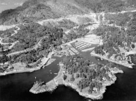
- Item is an aerial photograph of Eagle Island with Fishermans Cove in the background. Marine Drive, the BC Railway line, and Upper Levels Highway are at the top of the image. Eagle Harbour is at far right.
- Repository
- West Vancouver Archives
- Fonds / Collection
- Rupert Harrison photograph collection
- Description Level
- Item
- GMD
- photograph
- Date
- 1959
- Scope and Content
- Item is an aerial photograph of Eagle Island with Fishermans Cove in the background. Marine Drive, the BC Railway line, and Upper Levels Highway are at the top of the image. Eagle Harbour is at far right.
- Physical Description
- 1 photograph : b&w ; 21 x 25 cm
- Reference Code
- CA BWVA C030-S01-IT627
- Item Number
- 0627.WVA.RAH
- Accession Number
- 2000-004
- Geographic Access
- Eagle Harbour (West Vancouver, B.C.)
- Eagle Island (West Vancouver, B.C.)
- Fishermans Cove (West Vancouver, B.C.)
- Learn More
- Learn more about the above place(s)
- Notes
- Title based on the contents of the image.
- Copyright / Terms of Use
- Copyright ownership is undetermined. There are no restrictions on reproduction for research and private study. Permission of the copyright holder is required for all other uses.
- Repository
- West Vancouver Archives
- Other Formats
- Also available as a TIF (146.3 MB).
Images
