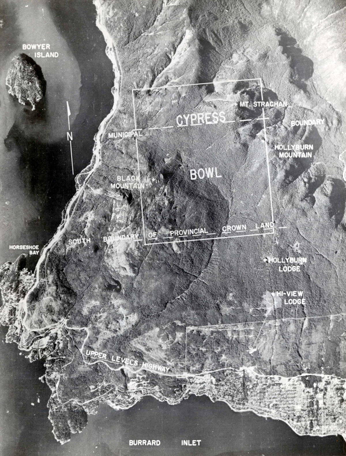
Aerial plan of Cypress Bowl boundaries
https://archives.westvancouver.ca/link/descr14777
- Fonds / Collection
- District of West Vancouver fonds
- Description Level
- Item
- GMD
- cartographic material
- Date
- [1967]
- Scope and Content
- Item is an aerial photograph of Cypress Bowl and surrounding area, with annotations depicting boundaries of provincial crown land, Hollyburn Lodge, Hi-View Lodge, Upper Levels Highway, Black Mountain, Hollyburn Mountain, Mount Strachan, and Horseshoe Bay.
- Repository
- West Vancouver Archives
- Fonds / Collection
- District of West Vancouver fonds
- Description Level
- Item
- Date
- [1967]
- Scope and Content
- Item is an aerial photograph of Cypress Bowl and surrounding area, with annotations depicting boundaries of provincial crown land, Hollyburn Lodge, Hi-View Lodge, Upper Levels Highway, Black Mountain, Hollyburn Mountain, Mount Strachan, and Horseshoe Bay.
- Physical Description
- 1 photograph : b&w ; 19 x 14 cm
- Reference Code
- 2150.02.101.DWV
- Item Number
- 2150.02.101.DWV
- Accession Number
- 2000-022
- Subject Access
- Parks
- Geographic Access
- Black Mountain (West Vancouver, B.C.)
- Cypress Bowl (West Vancouver, B.C.)
- Hollyburn Mountain (West Vancouver, B.C.)
- Horseshoe Bay (West Vancouver, B.C.)
- Howe Sound (B.C.)
- Mount Strachan (West Vancouver, B.C.)
- Upper Levels Highway (B.C.)
- Learn More
- Learn more about the above place(s)
- Notes
- Title based on the contents of the image.
- Photograph is affixed to a page in an album.
- Copyright / Terms of Use
- Copyright ownership is undetermined. There are no restrictions on reproduction for research and private study. Permission of the copyright holder is required for all other uses.
- Repository
- West Vancouver Archives
- Other Formats
- Also available as a TIF (35.8 MB).
Images