Aerial photograph of Whytecliff Park
https://archives.westvancouver.ca/link/descr30528
- Fonds / Collection
- District of West Vancouver fonds
- Description Level
- Item
- GMD
- photograph
- Date
- [1962]
- Scope and Content
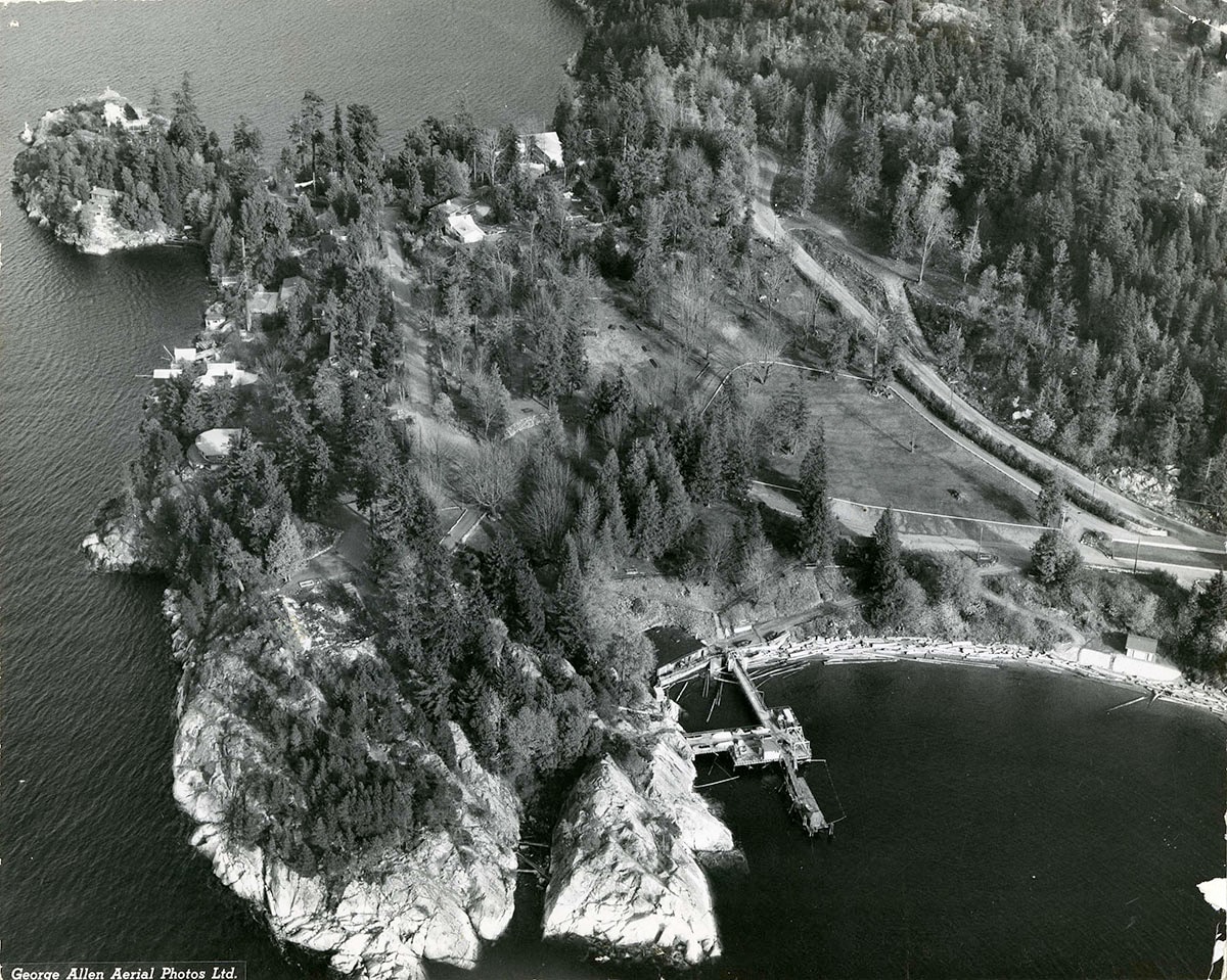
- Item is an aerial photograph of Whytecliff Park and the surrounding area. The beach and pier at Whyte Bay are in the foreground, Cliff Cove is at the top left, and house on Arbutus Road and Cliff Road are visible. The burned remains of Cliff House restaurant are in the clearing by White Cliff Point.
- Repository
- West Vancouver Archives
- Fonds / Collection
- District of West Vancouver fonds
- Description Level
- Item
- GMD
- photograph
- Date
- [1962]
- Scope and Content
- Item is an aerial photograph of Whytecliff Park and the surrounding area. The beach and pier at Whyte Bay are in the foreground, Cliff Cove is at the top left, and house on Arbutus Road and Cliff Road are visible. The burned remains of Cliff House restaurant are in the clearing by White Cliff Point.
- Physical Description
- 1 photograph : b&w ; 19 x 24 cm
- Reference Code
- 2150.03.610.DWV
- Item Number
- 2150.03.610.DWV
- Accession Number
- 2000-022
- Responsibility
- George Allen Aerial Photos
- Subject Access
- Geographic Features - Bays and coves
- Geographic Features - Beaches
- Geographic Features - Coasts
- Parks
- Structures - Piers and wharves
- Geographic Access
- Arbutus Road (West Vancouver, B.C.)
- Cliff Cove (West Vancouver, B.C.)
- Cliff Road (West Vancouver, B.C.)
- Whytecliff (West Vancouver, B.C.)
- Whytecliff Park (West Vancouver, B.C.)
- Learn More
- Learn more about the above place(s)
- Notes
- Title based on the contents of the image.
- Photograph is affixed to a page in an album.
- Copyright / Terms of Use
- West Vancouver Archives holds copyright. There are no restrictions on access or reproduction.
- Repository
- West Vancouver Archives
- Other Formats
- Also available as a TIF (41.1 MB).
Images