Map of colonial timber lease conducted in West Vancouver in 1869
https://archives.westvancouver.ca/link/descr4037
- Fonds / Collection
- West Vancouver Archives Maps and Plans collection
- Description Level
- Item
- GMD
- cartographic material
- Date
- 1869
- Scope and Content
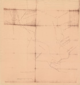
- Item is a map of a survey of timber lease in an area from Lost Lake in the north to Capilano 5 (IR) in the south, and from Hollyburn Ridge in the west to Capilano Creek (River) in the east. Tree types and sizes are noted on survey. The lease was acquired by S.P. Moody, Dietz, and Nelson in 1870.
- Repository
- West Vancouver Archives
- Fonds / Collection
- West Vancouver Archives Maps and Plans collection
- Description Level
- Item
- Date
- 1869
- Scope and Content
- Item is a map of a survey of timber lease in an area from Lost Lake in the north to Capilano 5 (IR) in the south, and from Hollyburn Ridge in the west to Capilano Creek (River) in the east. Tree types and sizes are noted on survey. The lease was acquired by S.P. Moody, Dietz, and Nelson in 1870.
- Physical Description
- 1 map : reproduction ; 58 x 51 cm
- Material Details
- Scale 20 chains to one inch [1:15, 840]
- Reference Code
- CA BWVA C003-F04-IT001
- Item Number
- 007.3.04.001.MAP
- Subject Access
- Geographic Features - Forests
- Industries - Forestry
- Geographic Access
- West Vancouver (B.C.)
- Learn More
- Learn more about the above place(s)
- Notes
- The map may have been drawn by timber cruiser Moses Cross Ireland.
- Copyright / Terms of Use
- Public domain. No restrictions on access or reproduction.
- Repository
- West Vancouver Archives
- Other Reference Number
- 227.WVA.MAP
- Other Formats
- Also available as a TIF (24.2 MB).
- Also available as a PDF (11 MB).
