
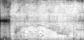
Area map of West Vancouver : No. 2 Company Pacific Coast Militia Rangers, Hollyburn Rangers
https://archives.westvancouver.ca/link/descr4039
- Fonds / Collection
- West Vancouver Archives Maps and Plans collection
- Description Level
- Item
- GMD
- cartographic material
- Date
- [between 1942 and 1945]
- Scope and Content
- Item is a topographic map which shows the elevations and streets of West Vancouver. Identified are visual signal stations, detachment headquarters, trails, bridges, observation points and other features of interest to the Pacific Coast Militia Rangers for civil defence purposes.
- Repository
- West Vancouver Archives
- Fonds / Collection
- West Vancouver Archives Maps and Plans collection
- Description Level
- Item
- Date
- [between 1942 and 1945]
- Scope and Content
- Item is a topographic map which shows the elevations and streets of West Vancouver. Identified are visual signal stations, detachment headquarters, trails, bridges, observation points and other features of interest to the Pacific Coast Militia Rangers for civil defence purposes.
- Physical Description
- 3 maps : 2 reproductions, 1 mylar ; 93 x 186 cm
- Material Details
- Scale 600 ft = 1 inch [1:7,200]
- Reference Code
- CA BWVA C003-IT171
- Item Number
- 171.WVA.MAP
- Accession Number
- 1994-051
- Name Access
- Hollyburn Rangers
- Pacific Coast Militia Rangers
- Subject Access
- Recreational Facilities - Trails
- Wars - World War II, 1939-1945
- Geographic Access
- West Vancouver (B.C.)
- Learn More
- Learn more about the above place(s)
- Copyright / Terms of Use
- Public domain. No restrictions on access or reproduction.
- Repository
- West Vancouver Archives
- Other Formats
- Also available as 1 photograph : b&w negative ; 60 x 32 cm.
- Also available as a TIF (40.9 MB).
- Also available as a PDF (51.9 MB).
Large Images
Area map of West Vancouver : No. 2 Company Pacific Coast Militia Rangers, Hollyburn Rangers
Zoom into Large Image