Aerial view of Sunset Beach
https://archives.westvancouver.ca/link/descr9745
- Fonds / Collection
- Rupert Harrison photograph collection
- Description Level
- Item
- GMD
- photograph
- Date
- April 27, 1960
- Scope and Content
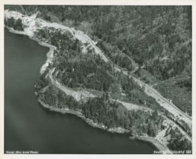
- Item is an aerial photograph of Sunset Beach at the northern boundary of West Vancouver. The view is north. The railway track is running along the shoreline, and the Sea-to-Sky Highway is behind. The bridge over Disbrow Creek is at top left.
- Repository
- West Vancouver Archives
- Fonds / Collection
- Rupert Harrison photograph collection
- Description Level
- Item
- GMD
- photograph
- Date
- April 27, 1960
- Scope and Content
- Item is an aerial photograph of Sunset Beach at the northern boundary of West Vancouver. The view is north. The railway track is running along the shoreline, and the Sea-to-Sky Highway is behind. The bridge over Disbrow Creek is at top left.
- Physical Description
- 1 photograph : b&w ; 20 x 25 cm
- Reference Code
- CA BWVA C030-S01-IT1138
- Item Number
- 1138.WVA.RAH
- Responsibility
- George Allen Aerial Photos
- Subject Access
- Transportation - Railroads
- Transportation - Roads
- Geographic Access
- British Columbia Highway 99 (Sea to Sky Highway)
- Sunset Beach (West Vancouver, B.C.)
- Learn More
- Learn more about the above place(s)
- Notes
- Title based on the contents of the image.
- George Allen Aerial Photos photograph number 1220.
- Copyright / Terms of Use
- Copyright held by the creator. There are no restrictions on reproduction for research and private study. Permission of the copyright holder is required for all other uses.
- Repository
- West Vancouver Archives
- Other Formats
- Also available as a TIF (42 MB).
Images
